Five West Sea Islands
Five disputed islands near North Korea, site of military clashes.

Rudyard Kipling · Public domain
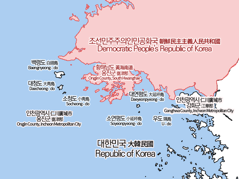
The Five West Sea Islands (also called the Five Islands of the West Sea or the Northwest Islands) are five islands in the West Sea (Yellow Sea) administered by Incheon, South Korea: Yeonpyeongdo, Baengnyeongdo, Daecheongdo, Socheongdo, and Soyeonpyeongdo. The islands are much closer to North Korea than to mainland South Korea, with Baengnyeongdo only 16 kilometers from Cape Changsan in North Korea and Yeonpyeongdo only 10 kilometers from the North Korean port of Pupori.
- location
- West Sea (Yellow Sea), administered by Incheon, South Korea
- islands
- Yeonpyeongdo, Baengnyeongdo, Daecheongdo, Socheongdo, Soyeonpyeongdo
- distance_from_North_Korea
- Baengnyeongdo: 16 km; Yeonpyeongdo: 10 km
- distance_from_Incheon
- Baengnyeongdo: about 200 km by boat
- religious_percentage
- approximately 75% (vs. 64% on mainland South Korea)
Lore & Background
The Five West Sea Islands are located in the middle of the maritime border between North and South Korea, and many major military clashes since the Korean War have occurred around them. Because of this, there are approximately 40 civilian bomb shelters on the islands.
Reader's Guide
The Five West Sea Islands hold strategic and symbolic significance in the ongoing conflict between North and South Korea. Their proximity to North Korea—Baengnyeongdo is only 16 kilometers from Cape Changsan, and Yeonpyeongdo is only 10 kilometers from the North Korean port of Pupori—makes them a flashpoint for military confrontations. The islands are also a nuisance for North Korea, as the southernmost North Korean military outpost at Haeju is visible from Yeonpyeongdo, and North Korean ship movements can be tracked from the islands. The only way to reach the islands is by ferry, with three round trips daily from Incheon Harbor to Baengnyeongdo, stopping at Socheongdo and Daecheongdo.
Did You Know?
- Baengnyeongdo is about 200 kilometers by boat from Incheon, making it the farthest island in the archipelago.
- Yeonpyeongdo is only 10 kilometers from the North Korean port of Pupori.
- Baengnyeongdo was part of the West Sea missionary route created by the first Catholic priest from Korea, Kim Taegon.
Naming and the Problem of Boundaries
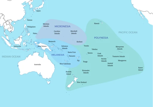
The Pacific Islands sit inside a tangle of overlapping definitions that shift depending on who is doing the defining. The islands are broadly sorted into three major groups—Melanesia, Micronesia, and Polynesia—yet the label 'Pacific Islands' itself can carry at least four distinct meanings. In one reading it captures only those islands whose populations trace back to Austronesian origins. In another it refers to islands that experienced European colonization after 1500 CE. A third usage treats the phrase as a synonym for the geographical region of Oceania, while the broadest reading simply means any island sitting in the Pacific Ocean. The people who call these islands home are collectively known as Pacific Islanders. Because the master list of islands is organized by archipelago or political boundary, and because some nations contain enormous numbers of tiny or uninhabited islets, more detailed country-by-country inventories are typically broken out into separate hyperlinked references to keep the main listing at a manageable length.
Biogeographic Subdivisions of the Tropical Pacific
In the 1990s, ecologists Dieter Mueller-Dombois and Frederic Raymond Fosberg proposed a granular subdivision of what they termed the 'Tropical Pacific Islands'—islands of oceanic geology spanning Melanesia, Micronesia, Polynesia, and the southeastern Pacific. Their framework carves the region into Western Melanesia (the Bismarck Archipelago, Bougainville, Buka, and the Solomon Islands) and Eastern Melanesia (the Santa Cruz Islands, Vanuatu, New Caledonia, and Fiji), alongside subtropical outliers such as Lord Howe and Norfolk Islands. Micronesia in their scheme covers the Bonin and Volcano Islands, the Marianas, the Caroline Islands, Nauru, Banaba, Wake, Palau, the Marshall Islands, and the Gilbert Islands of Kiribati. Polynesia is further split into Central (Johnston Atoll, the Phoenix and Line Islands, Tuvalu, Tokelau, and the northern Cook Islands), Western (Tonga, Samoa, Wallis and Futuna, Niue), Eastern (the remaining Cook Islands, the Austral, Society, Tuamotu, and Pitcairn Islands, Easter Island, and the Marquesas), and Northern (Hawaii). The Eastern Pacific adds the Revillagigedo, Cocos, Malpelo, Clipperton, Galápagos, Desventuradas, and Juan Fernández Islands.
Geopolitical Framing and Strategic Relevance
The political boundaries drawn around these islands have shifted dramatically across the twentieth century. In his 2007 volume Asia in the Pacific Islands: Replacing the West, New Zealand scholar Ron Crocombe argued that the phrase 'Pacific Islands' should politically encompass a sprawling list stretching from American Samoa and the Bonin Islands through Easter Island, East Timor, Guam, Hawaii, and dozens of smaller territories. He flagged that places like Easter Island, Norfolk Island, the Galápagos, and the Torres Strait Islands currently lack geopolitical ties to Asia but could gain strategic significance in an Asia-Pacific context. Crocombe also offered an alternative definition: islands served by the Pacific Community, the developmental body formerly called the South Pacific Commission, whose membership includes Australia and sovereign island nations. Decades earlier, American author Louis Morton, writing in his 1962 study War in the Pacific: Strategy and Command, had grouped the insular landmasses under the label 'Pacific World,' a term that swept in not just the three major island groups but also Australia, the Aleutians, Indonesia, Japan, the Philippines, the Ryukyu Islands, and Taiwan—all areas that featured in the Pacific Theater of World War II.
Oceania as a Shifting Conceptual Region
The grouping of Australia and the surrounding islands into a single region called Oceania dates back to the early nineteenth century, when geographers began treating the Pacific Ocean itself as the defining boundary of a quasi-continent. In 1879, British naturalist Alfred Russel Wallace described Oceania as a vast archipelagic world that continental geographers were mapping, noting that Australia formed its central and most important feature. Nineteenth-century definitions stretched the region from the Malay Archipelago to the shores of the Americas, and many geographers of that era carved it into subdivisions—Australasia, Malaysia, Melanesia, Micronesia, and Polynesia—largely along racial lines. By the 1990s, Australian author Stephen Henningham described Oceania in its broadest sense as incorporating every insular area between the Americas and Asia, potentially reaching as far as the Japanese and Malay Archipelagos, Taiwan, the Ryukyu and Kuril Islands, the Aleutians, and isolated Latin American islands like the Juan Fernández group. In practice, however, islands with deep geological and historical roots in the Asian mainland, along with non-tropical islands north of Hawaii, are rarely included in modern definitions.
Gallery
Frequently Asked Questions
What are the Five West Sea Islands?
They are a cluster of five islands—Yeonpyeongdo, Baengnyeongdo, Daecheongdo, Socheongdo, and Soyeonpyeongdo—located in the West Sea (Yellow Sea) and currently administered by Incheon, South Korea.
How close are the Five West Sea Islands to North Korea?
The archipelago sits remarkably near the North Korean coast: Yeonpyeongdo is only about 10 km away and Baengnyeongdo roughly 16 km, whereas the nearest point on the South Korean mainland (Incheon) is around 200 km by boat.
More in Islands Of The Pacific 1-19
Spotted an error? Know more?
This is a living reference — every entry is fact-audited, and reader corrections feed straight into our audit queue. Suggest an edit · See this site's audit record